
I’m sure for those of us stuck in daily slog of “rush hour” traffic, the arrival of the fully autonomous car can’t come a moment too soon. I mean, it’s the same thing every day—get into the traffic queue, get out of the traffic queue, get into another traffic queue, etcetera, etcetera, etcetera.
If you, like me, have fallen into the daily drive-time malaise then you’ll also, like me, follow the instructions of your onboard guidance councilor—the GPS. I’ve become a dutiful servant of Siri and Apple maps, providing me with directions home, and the exciting possibility of perhaps saving 2-minutes by taking a different route when available. Yes, this is probably how the machine uprising starts, but I don’t give a damn, I just want to get home before it gets dark!
What about you? Are you still riding dirty, not using the all-seeing powers of Google maps, Waze, or some other GPS navigator? Or, have you, like me, fallen under the spell? When you’re out and about, do you let your GPS tell you where to go?
Image: Easy Reviews
Hooniverse Asks: Do You Let GPS Tell You Where to Go?
About
32 responses to “Hooniverse Asks: Do You Let GPS Tell You Where to Go?”
-
Yes. My phone is very up-to-date on accidents and road construction. It’s generally correct when it tells me I can exit now and save 18 minutes by taking a parallel route.
-
My wife is a florist. I use navi when making deliveries for her. Otherwise, not so much.
-
Oh yeah, of course I let the GPS guide me – otherwise it takes some patience to find the reefs
http://fishingtackleretailer.com/wp-content/uploads/2015/07/humminbirdhelix7.jpg -
I used to not bother, but then again, I’d lived in the same metro area all my life (apart from college). When I got a job at Garmin and moved the the unfamiliar area of Kansas City (first time I visited was for the Garmin job interview), the first thing I did was dig a nav device out of a coworker’s desk and stick it on my dash so I could get around more easily while I learned the layout of the metro.
That was 7 years ago this April. I know the layout pretty well, but when I need to get somewhere I don’t frequent, I definitely open up Here We Go on my phone (Nokia’s nav app — highly recommended). When I need to get somewhere on time, I pull it out for the traffic alerts in case I need to deviate from my intended route.
The new-to-us 2014 Pilot is a Touring, and thus has Honda’s built-in nav system that’s currently out of date because I don’t want to pay the price of a while Garmin device for a map update. However, it was nice to use on our spring break roadtrip (first in this car) instead of a dash-mounted device or phone, and roads haven’t changed that much since 2014, so it was mostly correct. -
I didn’t until I started commuting ~35 miles into downtown Atlanta. The traffic navigation feature of Waze is really nice.
-
Here, not so much, since 80% of all long distance tours are:
– Get out of your home town
– Follow the national road for x dozens of miles
– Turn right where that signpost says “[Your Destination] ->”
– Follow the secondary road for x miles until you see the sign “[Destination]”
– You have reached your destination.
On German Autobahns, where many signs are often hidden behind thousands of semis in the right lane, I like the early warning (“turn right in 2km”) so I can inject me between the semis right on time. I also like the lane hints in bigger cities. This makes me a feel safer, since I don’t have to panic-squeeze me through the right lane to make an exit, or to play chicken race with a lane splitter. -
I live out in the country so I don’t really need a GPS. When I go into Houston, yes I need a map. On the other hand I’m finding these devices are not very helpful if you plan a road trip and just want to see what pops up.
-
Man, I’ll be back in Houston in a few weeks and all I know is that things will have changed since I was there at Christmas. I grew up there and wouldn’t drive without my phone/gps, especially in Spring, Tomball, Woodlands, etc. New roads be popping up everywhere. Plus the construction, oy..
-
-
If I don’t know where I’m going, like I’m in an unfamiliar city, I will use it, and I did replace a phone once entirely because the old phone – a blackberry – had badly done mapping, though that was many years ago. But since I mostly go places where I know where I’m going, programming it is more of a hassle.
-
It depends. Puget Sound traffic can be punishing, but often times Waze will route you in weird ways just to shave off a minute.
That said, if it tells me multiple times to get off the freeway, I now heed its advice. I ignore it at my own peril. -
Thanks to Hooniverse, I’ve been on waze for 5 years (?).
I’ll use to to drive 3 miles to the grocery.
A few times Waze directed me away from my usual route only to find out there was a major wreck ahead. For the most part I’ll let Waze take me unless I know the alternate route has long red lights that make it a zero net gain.
Oh – with 10k to 20k Wazers online around me, there’s hardly a time a cop isn’t reported. -
I use Google navigation sometimes, especially when I’m in an unknown area and want to “take the long way home”. Eastern Norway has mile upon mile with gravel roads, logging roads etc that are hard to identify on a map, but Google has most of them. Unfortunately, I tend to forget that once you turn it off (e.g. during a break) the Google navigation app struggles to pick up where you are, instead of starting at the starting point. Had me annoyed a couple of times.
Waze is a bit scary, to my mind. Maybe surprisingly to some, cough, I am a privacy advocate and this stuff is wild. On Android at least one can turn stuff like that off, one by one, but as fantastic as Waze is, the downside is too much to me.-
I agree. Waze is crap. It is basically social media lamely disguised as a navigation app, encouraging users to poke and prod at it while driving. Yay distractions, yay breaking the law using a wireless device while operating a moving vehicle. And did someone mention privacy issues? 😉
I have never found its crowdsourced data to be reliable. One accident reported in five different locations in a three mile stretch is kind of useless. Construction areas are usually not marked and on the flip side, areas that *are* marked usually don’t have any issues whatsoever. And the “cop stalker” feature is not even needed–if you’re not out violating traffic laws, you have no need to know where they are located. And neither do the criminals, or cop haters.-
i’ve always found Waze to be eerily accurate and i am especially happy to know where the police are, because i am out violating traffic laws, and you probably are too.
-
-
-
Occasionally. A few years ago I received a TomTom EASE as part of my HSNC gift package and, three years ago, found it useful while house hunting. It turns out that most real estate descriptions that include phrases like “large garage” or “spacious off-street parking” are, to put it charitably, filthy lies, so for a few months our weekends consisted of driving to see twenty or so promising listings per day, typically without even bothering to get out of the car once we saw each place. I admit it was nice being able to drive efficiently from one unfamiliar area to another with little trouble.
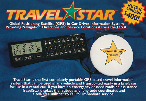
I also brought it along on last year’s LeMons rally just to see what it would do. I now know there have been some signficant changes to at least a couple of key surface streets in Las Vegas since its map was made. For this year’s West Coast rally I instead have a TravelStar, which wisely eschews electronic mapping altogether:
https://farm9.static.flickr.com/8462/29168420521_907c9c889f.jpg -
95% of my driving is to and from work (where my commute is really short, and in the event of any major backup, I can escape and find an alternate route without advanced warning), around town, or to places where saving two minutes isn’t a big issue. At best, I’ll check somewhere out on Google maps before I leave to figure out where I’m going, and confirm the route I would have taken anyhow is probably fine.
Waze would’ve helped yesterday though, as I went out of town and got caught on the highway for an hour because of an accident closure. But I survived though, and didn’t have to go Donner Party on anyone, so ehh?-
“didn’t have to go Donner Party on anyone” is the phrase i will henceforth use to describe success of any trip
-
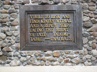
The plaque on the memorial at the pass is a model of deliberately vague circumspection.
https://s3.amazonaws.com/gs-waymarking-images/13867c02-a880-4fc7-a0d9-101df7e1486b_d.jpg-
probably preferable to HERE MAN ATE MAN
-
I was going to say: Indomitable-unafraid-and Hungry.
-
-
-
-
-
I’m just old enough that I learned to get around before GPS navigation became a thing. Between just having an above average fascination with maps and liking the feeling of not being lost, I built up a solid navigation skillset. The nail in the coffin was driving in downtown SF with an early GPS unit and saying, “hey, I’ll try this out and let it give me directions”, and then having the buildings block out the satellites and getting bad directions from the GPS.
I’ve since built up my fleet more to my liking, and all my vehicles are pretty unfriendly to navigation systems. The Jeep just has too much NVH. You can’t hear the directions. And then my motorcycles have that problem and no where to mount them. Yeah, yeah, I know there are handlebar mounts and bluetooth, but really, I want to put all my focus on the ride. And I have that navigation toolkit. It doesn’t solve any problems that I don’t already have solved, so the ergonomics of using them with my preferred chariots just adds problems and complexity to my life that I don’t need.
So. Yeah. It’s been 10 years since I let a GPS tell me where to go. Admittedly, I have had passengers read from a navigating GPS app at me, but I’m paying attention to them, not the phone, and often asking them detailed questions that the GPS didn’t answer that help me stay on the route. When I’m by myself, I just memorize the route and run it. Either all at once or I pull over and memorize the next set of turns periodically through the drive. It works for me.-
Yea I’m old enough to remember getting paper maps for free from AAA and gas stations. Then I got lost big time when a rural exit was now a maze of shopping and chains. Made worse that it was at night and very little signage. I pulled over and called my brother and we spent about 20 minutes figuring out where I was and how to get back on the right track. Next I had a Garmin and it directed me thru that maze perfectly.
-
Oh yeah, out of date paper maps can be terrible. I definitely make heavy use of google maps, but I use it as a map that knows where I am, not a navigation system. IOW: I’m sticking to the “print out the mapquest directions” technology level (although, I don’t have a printer, so I often just write it down; which helps a lot with memorization).
-
-
This is basically what I do as well. I’ll use paper maps or write down the directions before hand to get me relatively close to were I’m going, then use Google maps as an interactive map to get the rest of the way (especially in urban areas).
-
-
I use Google Maps on my phone to find unfamiliar locations and to seek better routes sometimes. The rest of the time I work from local knowledge. I used to use street atlases a lot but a phone is much easier to use.
We just got a car that has optional navigation, but $400 for the magic SD card doesn’t seem worth it compared to a phone and a cheap dash mount. At least the nav display shows a compass and latitude/longitude and you can use the GPS to set the clock so they didn’t totally cheap out. -
I only use it if I’m going somewhere I don’t know.
A local paper tested Google Maps vs Apple Maps vs Waze to see which was better, and Waze won on time due to re-routing around slowdowns. I should use Waze more often – normally use Google Maps – especially on the route home when there’s traffic. -
The traffic thing would have been handy last night, when it took an hour to do 4.6 miles due to a set of traffic lights being out.
I usually use it for work trips interstate where I have to visit a lot of out of the way sites. Going back a few years though, I twice drove across Sydney without a GPS or map, staying off the motorways. Once I didn’t put a foot wrong, the other time driving from Woollongong out over the Blue Mountains I did get a bit off-track when at one point I didn’t know where I was, but I wouldn’t say I was lost if that makes sense? -
Don’t have a GPS, but I do use a 17 year old street directory. Interesting to see Sydney streets in the header image. it looks like they are heading north up George St, which you can’t do that much any more as it is a building site..
-
In my day to day driving, no. But if I am going any distance or driving through rush hour, seeing the live traffic overlay in Google Nav has saved me many times. I also see it popping up a faster alternate route when traffic gets heavy, and that is a great feature for me. I’ve used it heavily on trips, at times relying only on the voice as traffic is too hectic to take eyes off the road. It got me safely out of the Boston airport onto some local side roads in heavy traffic and back onto a freeway heading north, and I had no clue where I was going otherwise. It has taken me on a 19 hour marathon drive from home to central Maine without a single wrong turn, even redirecting me around construction on the Southern Tier Expressway through New York.
The one time I didn’t follow its instruction was about six years ago. Heading back from Parris Island SC late one January day, we were doing well until I noticed the driving time bumped ahead by three hours. I saw a stretch in West Virginia that was solid red. How could there be road construction in the middle of January, out in the middle of nowhere? We hit that area as dusk fell, and came across what was essentially a very long traffic jam. Some oldtimer driving an 18-wheeler had ridden the guardrail for a mile before flipping his rig, hauling hazardous chemicals, on the freeway. It took us over an hour and a half to crawl less than a mile to the next turnaround, then cut back to the previous exit (where I learned the freeway had been closed all day). I should have paid attention to the traffic notice–I could have rerouted and gone up I-75 instead. Luckily, the navigation got us through the back hills of WV to pick up I-64, and got around it all.
So, no…I don’t leave home without it. Indispensible. I have been using a 7″ tablet for nav, but recently got an Android Auto in-dash so I can run Google Nav on it, and not have wires draped all over the place.
Waze is crap. The poor, low-grade and unreliable crowdsourced data ruins it, not that its cartoonish interface can be taken seriously anyway…-
What you said about not using it that one time you really needed it.. been there. Now I don’t like to drive most anywhere without it. Recently, I left a place in DC to drive a short distance back to NOVA; I knew the way but had the GPS running anyway. Turns out there was an accident that had the freeway (295) pretty much shut down. The system guided me through the wilds of NE DC without a hitch. Awesome.
-
-
my garmin has a sextant logo on power up.. any one know what that means?
-
permanently mounted the garmin and power supply in the mark 8. take an act of hammer to get it out. wired to the run only buss. don’t have to flick the switch on top. shuts off when the door opens and kills the delayed power relay. works out for me. next to the inside mirror.
better than the phone. don’t loose gps when using a phone. battery doesn’t run down. garmin has better updates that tomtom/megalin/what ever. loud audio.
didn’t like the built in gps in a lot of cars that have the display at the radio. not having to look down away from the road is a plus for me. it is in my normal scanning vision. just like checking the mirror.
still, maps are for planning. gps is for situational awareness. all good.
Leave a Reply